Wednesday, May 12, 2010

Aftermath & Future of the New Madrid Territory

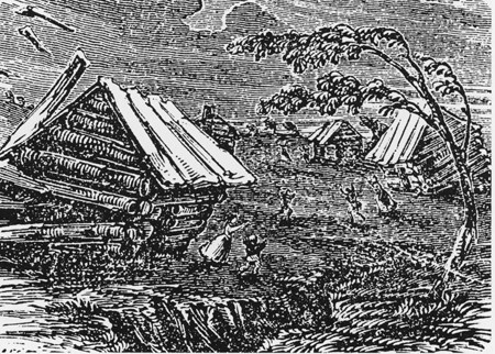
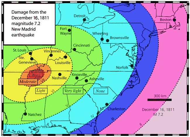
The New Madrid Earthquake of 1811-1812 was actually a series of over 2000 shocks in five months. Some seismologists estimate that five of the New Madrid shocks were 8.0 or more in magnitude. Eighteen of these rang church bells on the Eastern seaboard. The very land itself was destroyed in the Missouri Bootheel, making it unfit even for farmers for many years. It may have been the largest burst of seismic energy east of the Rocky Mountains in the history of the United States and some estimates place it at several times larger than the San Francisco quake of 1906. [5]


Most accounts place the three strongest temblors of the New Madrid series of earthquakes at 7.7, 7.7 and 7.5 respectively. If one was to compare the New Madrid earthquakes to the strongest seismic events in all 50 states, the New Madrid earthquakes ranked at 18, 19, and 20 out of the 20 strongest earthquakes to strike the United States. To give the reader an idea of just how powerful the New Madrid events were, the San Francisco earthquake of 1906 measured in at a magnitude  7.8. The majority of this nation’s most powerful earthquakes have taken place in the sparsely populated areas of Alaska. 12 out of 20 of this nation’s most powerful seismic events occurred in Alaska. In comparing the New Madrid event to just earthquakes to occur in the lower 48 states, the New Madrid event would ranks as the fifth, sixth and seventh, out of the top 15 most powerful seismic events to hit the lower 48 states. [1]

                                                                             [6]

Yet, other sources list the magnitude of the February 7, 1812 New Madrid quake as high as 8.8, which would place that single seismic event as the  second most powerful; and if more conservative estimates of  7.7 still possibly the third most powerful seismic event to ever strike in any of the 50 states, and the second most powerful earthquake event to hit in just the lower 48 states. [1]

The primary reason why the loss of life and property was so low in regards to the series of New Madrid earthquakes was due to the simple fact that the New Madrid Territory was sparsely settled and populated at the time. When comparing the magnitude and damage of the New Madrid earthquake with that of the San Francisco earthquake, the two earthquakes were similar in magnitude being separated by just one tenth of a degree in magnitude, as each whole number increase in magnitude represents a tenfold increase in measured amplitude. [2][3]

The destruction caused by the San Francisco earthquake event was severe due to the population center of San Francisco being situated almost on top of the epicenter of the earthquake, which was just two miles off shore. In geologic terms, the epicenter of the San Francisco earthquake can be considered a direct hit on San Francisco. [4]

     Panoramic View of San Francisco after the 1906 earthquake  [7]

At the time of the San Francisco earthquake, 3000 deaths were reported. Additionally, hundreds of casualties in Chinatown went ignored and unrecorded. Most of the deaths occurred in San Francisco itself, but 189 were reported elsewhere in the Bay Area. In nearby cities, such as Santa Rosa and San Jose severe damage occurred. In Monterey County, the earthquake permanently shifted the course of the Salinas River near its mouth. Where previously the river emptied into Monterey Bay between Moss Landing and Watsonville, it was diverted 6 miles south to a new outlet just north of Marina.

Between 227,000 and 300,000 people were left homeless out of a population of about 410,000; half of the people who evacuated (evacuees) fled across the bay to Oakland and Berkeley. Newspapers at the time described Golden Gate Park, the Presidio, the Panhandle and the beaches between Ingleside and North Beach as being covered with makeshift tents. More than two years later in 1908, many of these refugee camps were still in full operation. [4] Had the New Madrid territory resembled San Francisco at the time of the New Madrid earthquake, the loss of life and property would have been much higher.


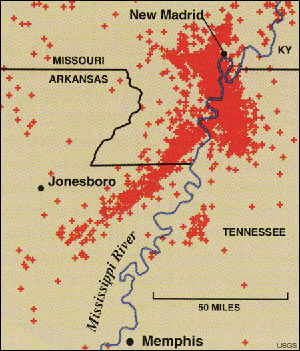
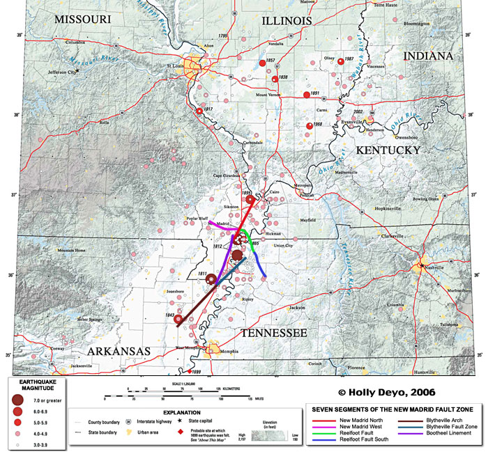
The New Madrid fault system extends 120 miles southward from the area of Charleston, Missouri, and Cairo, Illinois, through New Madrid and Caruthersville, following Interstate 55 to Blytheville and on down to Marked Tree, Arkansas. It crosses five state lines and cuts across the Mississippi River in three places and the Ohio River in two places.

                                                                           [6]

The fault is active, averaging more than 200 measured events per year (1.0 or more on the Richter scale), about 20 per month. Tremors large enough to be felt (2.5 - 3.0 on the Richter scale) are noted annually. Every 18 months the fault releases a shock of 4.0 or more, capable of local minor damage. The most recent registering 4.3 along the New Madrid Fault on Thanksgiving evening, 1996, which was felt by citizens in the states of Missouri, Arkansas, Tennessee and Kentucky, Illinois and Mississippi. Magnitudes of 5.0 or greater occurring about once per decade, can do significant damage, and be felt in several states.

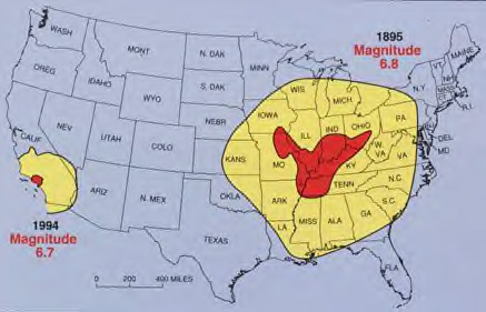
The highest earthquake risk in the United States outside the West Coast is along the New Madrid fault. Damaging tremors are not as frequent as in California, but when they occur, the destruction covers over more than 20 times the area because of underlying geology.

A major earthquake in this area, 7.5 or greater, happens every 200- 300 years (the last one in 1812). There is a 25% chance by 2040. A New Madrid Fault rupture this size would be felt throughout half the United States and damage 20 states or more. Missouri alone could anticipate losses of at least $6 billion from such an event. [5]

                                                                             [6]


11 million people live in the New Madrid Seismic Zone. Geologists the earthquake center at the University of Memphis, have predicted that a magnitude 8 earthquake could occur in the New Madrid zone every 550-1,000 years. Because of shock effects, such a quake could cause tens of billions of dollars worth of damage from Mississippi to Michigan, leveling Memphis and seriously damaging St. Louis. A magnitude 7 earthquake could occur within 50-100 years, and one registering magnitude 6 could occur at any time, according forecasts. [6] Tens of thousands could be killed in such a disaster. Yet, preparedness for the ‘Big One‘ in this area is low. A large and devastating earthquake has never hit in living memory. The people living in the former New Madrid territories and the surrounding areas have grown complacent, which reminds us of the old saying; out of sight, out of mind.


[1] http://earthquake.usgs.gov/earthquakes/states/10_largest_us.php
[2] http://earthquake.usgs.gov/earthquakes/states/events/1906_04_18.php
[3] http://en.wikipedia.org/wiki/Richter_magnitude_scale
[4] http://en.wikipedia.org/wiki/1906_San_Francisco_earthquake
[5] http://www.scchealth.org/docs/ems/docs/prepare/newmadrid.html
[6] http://www.greatdreams.com/madrid.htm
[7] http://en.wikipedia.org/wiki/File:San_Francisco_1906_earthquake_Panoramic_View.jpg

Wednesday, March 31, 2010

Damage Caused By The New Madrid Earthquake 1811-1812

The frontier settlement of New Madrid in the Missouri territory, was founded at the end of the 18th century, in 1789. At the time of the New Madrid Earthquake the settlement had several thousand inhabitants of settlers and Native-Americans. New Madrid sat on the fringes of the western settlement of the United States. [1]

The typical settler lived in a log cabin type structure without any improvements. Travel was accomplished by horse and or horse drawn wagon on crude wagon trails. Where swaps existed on the banks of the Mississippi river, wood planks were occasionally lain down on top of the mud to accommodate travel. The Mississippi river, its tributaries and associated lakes allowed for river travel and commerce to take place. [1]

The four main shocks that shook the New Madrid area occurred over a three and a half month period, beginning in December, 1811. Current day estimates place the magnitude of the four main shocks at possibly 8.4  on the Richter Scale, or greater. [1]

At the time, the sparseness of the population probably accounts for the low loss of life.  The aftereffects of the series of earthquakes are described by Eliza Bryan in a letter she penned as an eyewitness to the events of the day. Bryan wrote; “We were constrained by the fear of our houses falling to live twelve or eighteen months, after the first shocks, in little light camps made of boards; but we gradually became callous, and returned to our houses again. Most of those who fled from the country in the time of the hard shocks have since returned home.” [2]

Bryan’s description tells us that many residents of the area abandoned their homes to live in makeshift shacks, out of fear that their log homes would collapse during subsequent aftershocks. Others actually migrated out of the area, only to return months later. The fear of falling homes must have been justified, as most homes of the time were not of a rigid type of construction, but rather of heavy logs that were notched at both ends, and then placed atop one another. The logs were held in place by weight and friction. [3]


 Typical Log Cabin Construction Technique [4]

The roofs of many cabins were constructed of sod and earth.  The jarring and shaking of an earthquake could easily cause the heavy logs to bounce apart and a stout roof to cave in. [1]

The Great Earthquake at New Madrid. A nineteenth-century woodcut from Devens' Our First Century (1877)

Other accounts tell us that trees toppled over, and that the direction of the Mississippi river change course for at least twenty-four hours on one occasion, to fill in an earthquake caused sinkhole that would later become Reelfoot Lake. As the Mississippi River ran upstream, boats used to bring supplies in and take goods out, broke from there moorings and drifted into one another to stack up like cordwood. Other boats were washed up onto the riverbanks.

The damage to settler’s homes and to property was significant enough to prompt Congress to pass the Disaster Relief Act of 1815. [1]

The economic hardship and fallout from the New Madrid Earthquake lasted another fifty years.  Author and Historian, Jay Feldman wrote of the effects of the New Madrid Relief Act of 1815, which follows:


“On February 17, 1815 [three years after the strongest earthquakes in U.S. history], Congress passed the New Madrid Relief Act, the first federal disaster relief act in U.S. history. Unfortunately, the act itself turned out to be a disaster.

The legislation provided for residents whose land had been damaged in the earthquakes to trade their land titles for a certificate that would be good for any unclaimed government land for sale elsewhere in the Missouri Territory. The only restriction was that the new grants had to be between 160 and 640 acres, regardless of how much or little land a person had previously owned. Well-intentioned though the legislation was, it did little to help the residents of the New Madrid area.

Communications being what they were, word of the New Madrid Relief Act did not reach the New Madrid area for months. News did reach St. Louis and other places, however, and speculators were soon beating a hasty path to New Madrid and buying up land for a pittance from unsuspecting locals. Of the 516 certificates issued for redemption, only twenty were held by the original landowners. Three hundred and eighty-four certificates were held by residents of St. Louis, some of whom had as many as forty claims. Adding insult to injury, many banks in Missouri failed, making the Missouri banknotes used to pay for these claims worthless. Governor Clark himself was not above profiting from the situation, as he authorized two of his agents, Theodore Hunt and Charles Lucas, to purchase land in the New Madrid area. Meanwhile, opportunists in New Madrid caught on to what was happening and began selling their land titles many times over. Before too long, the term "New Madrid claim" came to be synonymous with fraud.

Litigation over the resulting land claims tied up the courts for over twenty years, with hundreds of fraudulent claims being pressed. Over the next three decades, Congress passed three more pieces of legislation to try and straighten out the mess. The last case stemming from the New Madrid Relief Act was finally settled in 1862, fifty years after the earthquakes of 1811–12—by which time the frontier had moved a thousand miles west.” [6]


[1]Environmental Geology Volume 16, Number 1 / July, 1990
J.D. Rockaway - The great New Madrid, Missouri (U.S.A.) Earthquake of 1811–1812 pp 29-34


[2]The Virtual Times - The New Madrid Earthquake http://www.hsv.com/genlintr/newmadrd/accnt1.htm

[3] Log Cabin Construction http://architecture.about.com/od/periodsstyles/a/logcabins_2.htm

[4] Image: http://z.about.com/d/architecture/1/G/Z/H/logcabin-construction.jpg

[5] Image: http://upload.wikimedia.org/wikipedia/commons/1/11/New_Madrid_Erdbeben.jpg


[6] When the Mississippi Ran Backwards: Empire, Intrigue, Murder, and the New Madrid Earthquake, by Jay Feldman (Free Press, 2005), p. 236


Sunday, February 28, 2010

The New Madrid Earthquake of 1811

 
Purdue University [4]

31-year old Eliza Bryan soundly slept next to her husband, an Army surgeon. Their son, Fredrick slept across the room in his warm bed. The small family resided under the same roof as Eliza’s mother in her New Madrid Territory boarding house, in what is now Missouri.[1]
It was around 2:00 a.m., the morning of December 16, 1811, when the Bryan family was jolted from their sleep by a low rumbling noise accompanied by the violent shock of an earthquake. As the Bryan family was shaken from their beds, the sounds of their neighbors screaming could be heard in the darkness.  People could be heard running about panic-stricken.

Mixed in with the cries of their neighbors, Eliza could make out the panicked sounds of livestock and fowl. The sound of cracking of trees was quite evident as they were knocked over and snapped like twigs, so violent was the trembler. Even the mighty Mississippi River was halted where it flowed, only to flow in reverse, back up stream. The Bryan family was horrified as the events of the early morning played out. Their world was being shaken to its very core.

Shortly after the shaking stopped, Eliza and her neighbors noticed ‘the complete saturation of the atmosphere, with sulphurous vapor, causing total darkness.’[2] So violent was the earthquake, that noxious gasses had been shaken and released into the atmosphere. Myron Fuller wrote; "The source of the odors in the New Madrid region seems to have been the buried organic matter, which here as elsewhere in the Mississippi embayment, occurs in the alluvium and underlying Tertiary deposits, the emanations coming mainly from the carbonaceous material extruded from below through the fissures and craterlets, which were numerous in the region." [3]

As the night wore on, more aftershocks occurred. Eliza and her family most certainly would have been relieved as sunrise approached and as the aftershocks began to subside in intensity, although not all of the shocks were less in intensity. One aftershock was felt to be severe enough to actually rival if not surpass the intensity of the original earthquake. As the aftershocks happened, the people remained unsettled and frightened.

Eliza observed that “The inhabitants fled in every direction to the country, supposing (if it can be admitted that their minds can be exercised at all) that there was less danger at a distance from, than near to the river.” [2] So panicked were the people that one woman even fainted, and then died from the fright.

As time went on, there were fewer and less intense aftershocks until January 23, 1812. On that day another severe quake as intense as any of the former shakers occurred. The quakes continued through February 4.  Eliza thought the earth had been in an almost continual motion and state of agitation for weeks.

On February 7, again in the early morning hours at about 4:00 a.m., another earthquake manifested itself of an intensity that was more violent than any of the earthquakes that had preceded it in weeks past. All of the events that occurred during the original quake accompanied this latest and more severe earthquake.

With this latest shock, the Mississippi River receded its banks so violently that stands of cottonwood trees were snapped by fifteen to twenty foot waves, while boats that had been passing through on their way to New Orleans were deposited on bare sand. Then the waters returned, flowing back down the river, tearing the boats from their moorings and sending them up another creek nearly a quarter mile. Fish were strewn on the banks of the river and Eliza noted that the entire Mississippi River was strewn with the wrecks of boats. One boat was destroyed, killing a woman and six children. 
 
Scene On Mississippi River, New Madrid, Mo.


Soon, the quakes began to quiet down and people began to rebuild their lives. Some had permanently moved away, fearing more quakes. Others stubbornly dug in and began to reclaim their lives. Eliza Bryan observed as an eyewitness some  of the after effects of the earthquakes, which she describes; “The site of this town was evidently settled down at least fifteen feet, and not more than a half a mile below the town there does not appear to be any alteration on the bank of the river, but back from the river a small distance, the numerous large ponds or lakes, as they are called, which covered a great part of the country were nearly dried up. The beds of some of them are elevated above their former banks several feet, producing an alteration of ten, fifteen to twenty feet, from their original state. And lately it has been discovered that a lake was formed on the opposite side of the Mississippi, in the Indian country, upwards of one hundred miles in length, and from one to six miles in width, of the depth of ten to fifty feet. It has communication with the river at both ends, and it is conjectured that it will not be many years before the principal part, if not the whole of the Mississippi, will pass that way.” [2]  Eliza also described that in other parts of the country and surrounding area, numerous lakes and ponds were elevated above their banks with many drying up.

Meanwhile, for about 18 months after the event, Eliza, her family, and other families moved from their homes into makeshift shacks for fear that their homes would collapse. Eventually, as the earthquake activity subsided, many moved back into their homes, and the years went on as generations passed. The New Madrid Earthquake became but a distant memory and soon would become an almost forgotten and minor footnote of the past.

 
Downtown New Madrid in 1920s [5]

Epilogue

Wikipedia reports the following about the New Madrid Seismic Zone and the potential for a future earthquake; "The New Madrid seismic zone had four of the largest North American earthquakes in recorded history, with moment magnitudes estimated to be as large as 8.0, all occurring within a three-month period between December 1811 and February 1812.
 
In a report filed in November 2008, The U.S. Federal Emergency Management Agency warned that a serious earthquake in the New Madrid Seismic Zone could result in "the highest economic losses due to a natural disaster in the United States," further predicting "widespread and catastrophic" damage across Alabama, Arkansas, Illinois, Indiana, Kentucky, Mississippi, Missouri and particularly Tennessee, where a 7.7 magnitude quake or greater would cause damage to tens of thousands of structures affecting water distribution, transportation systems, and other vital infrastructure.

The potential for the recurrence of large earthquakes and their impact today on densely populated cities in and around the seismic zone has generated much research devoted to understanding in the New Madrid Seismic Zone. By studying evidence of past quakes and closely monitoring ground motion and current earthquake activity, scientists attempt to understand their causes and recurrence intervals."[7]


Sources Cited

[1] Center For Earthquake Research and Information
[2] The Virtual Times - The New Madrid Earthquake
[3] Myron Fuller - The New Madrid Earthquake (A Scientific Factual Field Account) (1912) pp.45-46
[4] Purdue University Map
[5] Scene On Mississippi River, New Madrid, Mo.
[6] Downtown New Madrid in 1920s
[7] Wikipedia - New Madrid Seismic Zone